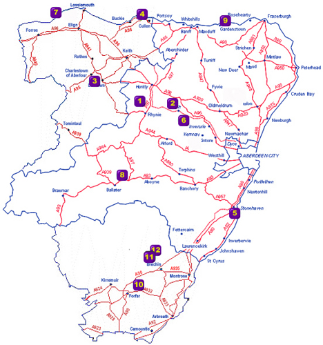
Hill Forts and other Settlements

 1. Tap O'Noth
Access is by a steep footpath from a small carpark at Brae of Scurdargue, 1.5 miles (2.4km) N of Rhynie on A941 to Dufftown.
 2. Dunnideer
Access is by a steep, signposted footpath from the minor road B992 from Insch, about 1 mile (1.6km) W of Insch.
3. Little Conval
2 miles (3.2km) W of Dufftown, the B9009 passes the lower slopes, with tracks leading W towards the hill. Access is on foot via marked footpaths.
4. Green Castle, Portknockie
Access is by a rough track that leads from Patrol Road to the harbour. On street parking in the vicinity.
 5. Dunnottar Castle and Dunnicaer
Signposted off the A92 0.9 miles (1.4km) S of Stonehaven.
 6. Mither Tap O'Bennachie
6 miles (9.5km) W of Inverurie. Easiest route from N via steep footpath from Rowantree carpark, signposted from minor road W off A96. Alternatively from Bennachie Visitor Centre to E.
7. Burghead
At the NW end of Burghead itself, on street parking around the fort.
8. Kinord Sites
Lies between Loch Davan and Loch Kinord; paths lead to the site from carpark W off A97, 0.93 miles (1.5km) N of Dinnet. Also from B9199 to W, where parking and facilities are at the Burn O'Vat Visitor Centre.
 9. Castle Point, Troup (Cullykhan)
9.9 miles (15.9km) W of Fraserburgh. Turn N off the B9031 down a track to the carpark. Short walk of 150m to the fort.
10. Turin Hill
Lies on a ridge 3.4 miles (5.5km) E of Forfar, between the B9134 and the B9113. A track to the S of the B9134 leads to a path up to the fort.
11. White Caterthun
Track leads up hill W from minor road that runs between the Caterthuns about 4.6 miles (7.16km) N of A90 at Brechin.
White_Catherthun by Aberdeenshire Council Archaeology Service on Sketchfab
Please note: if using Internet Explorer, the full functionality of the 3D model may not work.
12. Brown Caterthun
Track leads up hill E from minor road that runs between the Caterthuns about 4.6 miles (7.16km) N of A90 at Brechin.
